
On Thursday we headed to Capitol Reef National Park. The whole area is full of beautiful, layered, red rock formations. On the way to the visitor center we stopped at a viewpoint. In the picture above, you can see chimney rock all the way to the left. We went to the visitor center to pick up a guided tour of the park’s scenic drive, but we stopped to watch a short documentary about the park. It was probably made in the 2000s and every time they showed reenactments of people living in the park, they made the people transparent, which Duncan thought was very funny. We headed on the scenic drive, which had numbered stops, and the guide we bought described each stop. It mainly talked about the rock formations, what the layers were and how they were formed. Duncan was a big fan of the guide and he said we learned more about this park than any other.

One of the stops had a very distant view of an arch called the Cassidy Arch because there are some (unsubstantiated) reports that the famous outlaw, Butch Cassidy, used the arch as a hideout. We decided to do the hike up to the arch (which was labeled strenuous on the park map) and I regretted it. We got a later start on this hike than our previous ones and it was so HOT. Like 100 degrees. We got to a point where we could see the arch and that was enough. If we’d finished the trail we could have gone on top of it but what’s the point of that? You can’t see the arch from on top of it.

We continued on the scenic drive but found that the road to the final two stops was closed. Before we realized this, we went down a different road that was very bumpy and led nowhere. To see the final stops, we would have to walk over two miles down the closed road, which was not worth it. One of the final stops was petroglyphs, and I was disappointed to not be able to see it. Capitol Reef lost a lot of points in my mind for this. Capitol reef was home to a small group of early Mormon settlers and they planted orchards in the valley that the scenic drive winds through. On the way out, we stopped at the historical society, which sells locally baked pies, and bought a strawberry rhubarb pie because it’s Duncan’s favorite.

As we left the scenic drive and the visitor center, we saw a sign on the road for petroglyphs. We pulled in and there was a boardwalk where you could walk along an edge of rock that had a bunch of petroglyphs on it. These are images that were carved in the stone by natives sometime between 300 and 1300 C.E. Some of them were so faint I didn’t notice them until I was walking back. The picture below shows the clearest ones. This made up for some of my disappointment with the scenic drive.

We got on the road towards our next motel and the drive was one of the most interesting things we’ve seen. The landscapes were extremely varied and changed rapidly. The red rocks of Capitol Reef changed to multicolored mounds, then to monochrome barren landscapes, then to multicolored mounds of a different color scheme. So many of the environments looked like another planet; it was so cool. The pictures below aren’t even all of it. There were at least five more distinct landscapes that I didn’t get good pictures of. All of these occurred within a 45 minute drive.


We rested in the hotel for a bit, got dinner, and in the evening drove to Goblin Valley State Park. Goblin valley is known for hoodoos, but they look pretty different than the ones in Bryce Canyon. We got to the park right around sunset, but a storm cloud in the distance blocked the nice sunset view I was hoping for. It was still nice to see the park in the light of the sunset. We took a short hike around the goblins. The trails were not very well marked and it seemed like the park administrators had left us to wander around in the desert.


This formation was called the three sisters + Duncan.
The park has a big area called the valley of the goblins where there are hoodoos everywhere and you can freely wander around them. By the end of our hike, a thunder storm was rolling in and blowing sand at us. We briefly checked out the valley of the goblins but it was pretty dark so we couldn’t see a lot. I specifically came to Goblin Valley at night because I heard the hoodoos look cool in the dark and there’s a great view of the stars, but the thunderstorm kind of messed up my plans. I had no idea it rained so much in the desert. We went back to the hotel and got a good night sleep.

The next day we started our long drive south towards the Grand Canyon. Before leaving, we went to the gas station across from our hotel so Duncan could get coffee. The gas station was cool because it appeared to be built inside a rock.

Along the way, we stopped at a viewpoint in Glen Canyon National Recreation Area, where there was a cool valley.

Our first planned stop was Natural Bridges National Monument, which is a smallish park that has three stone bridges. The park has a loop so you can drive to each viewpoint. Some views required short hikes that weren’t bad. We learned that the difference between a bridge and an arch is that bridges are formed from the flow of water from streams or rivers, while arches are formed primarily by erosion and freeze/thaw or other forces.


The park also had a cool viewpoint where you could see some structures in the cliffside left by the Peubloan people. There was a group of round structures and a group of square structures very close to each other on the cliffs but apparently were made by different groups of people. It was like a mini Mesa Verde (a national park we did not get to see).

We got back on the road and headed to Monument Valley. We got out to take a picture at the Forest Gump spot, which is the place in the movie where Forest quits his run and decides to go home.

In Monument Valley we got a guided tour from a Navajo man named Tony. He was funny and a great guide. We saw lots of interesting rock formations and places from movies. The tour was on a truck with seats attached to the back. It’s notable that throughout this trip, we’ve seen a lot of European tourists, specifically French speakers (it’s possible they’re Candadian but I think they’re European), at all the parks we’ve gone to. There were about a dozen other people on the tour with us, and ALL of them spoke French.

This formation is called the mittens.

Native vendors were selling things at some of the points in the valley and this vendor had a ton of dreamcatchers. The man said he made them himself. I was in heaven. I bought two (well, Duncan bought them for me). I bought a dream catcher at the visitor center before the tour and I wouldn’t have if I’d known this guy was out there.

Dead horse point. There was a horse here and a sign that you could pay three dollars to get a picture on it. Duncan would have done it but we couldn’t find the horse’s owner.

First (possibly only) cat of the trip!

This rock formation is called the sleeping dragon. Surprisingly accurate.

Who even needs to go to Arches national park? Not us.
Duncan and the rock cairn he made. In the background is a formation called the totem pole.

The thumb.
Our tour was 2.5 hours and ran over time so we were a bit late getting out of Monument Valley. We made the 3.5 hour long drive to the Grand Canyon and it was dark when we got there. We parked in a free, no-amentity camping area just outside the park. In the morning, we woke up bright and early at 5am to watch the sun rise over the canyon.

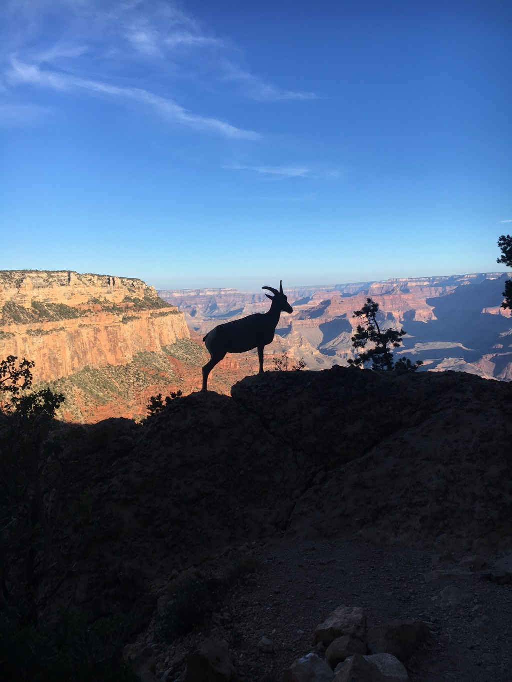
Next we did a short, 2 mile hike down into the canyon. We hiked in the early morning so it wasn’t hot. Along the way we saw a family of bighorn, which was really cool.

The hike was ok but honestly I thought the view from under the rim was not that different than the view from the rim. Also, our trail was used by mules so parts of it were covered in dung and smelled pretty bad.


Next we walked along the rim to a geology museum and attended a ranger-lead talk about the geology of the park. We learned that the way to remember how the grand canyon formed is DUDE: deposition, uplifting, downcutting, and erosion. Over millions of years, various layers of rocks were deposited. Then the Colorado Plateau was uplifted. The force of river water crossing the area cut down into the rocks, and the rest was erosion from rain and the freeze/thaw cycle. The ranger talked about plate tectonics and different kinds of rocks. Duncan said he learned a lot from the talk. I learned some stuff but less than Duncan because a lot of it was things I already knew. We continued walking along the rim and walked the Trail of Time, which had lots of different rock samples in order of how old they were. The trail eventually lead to a building called the Hopi House, which was a museum/store for Native American crafts, and Duncan and I both got stuff. We considered taking the shuttle to stops along the rim, but the line for the shuttle was long, and I felt like the canyon didn’t look that different from different angles. We left the park and went into town to watch an IMAX movie about the Grand Canyon. It was about the experiences of different people in the canyon and started with scenes of natives, then conquistadors discovering the valley, then some explorers trying to brave the rapids of the Colorado River. It was kind of weird and plotless. They had a random five minute segment about a man being stalked by mountain lions, and he shoots them and misses, then tried to put out a bear trap and gets caught in it himself. Then his story is over. The movie theater said this is the most watched IMAX movie ever, and I guess that’s because the Grand Canyon gets a lot of visitors and this is the only movie they play.
That’s all for my park visiting with Duncan. We got on the road to Phoenix to meet my mom. Phoenix was soooo hot. Like, sand dunes of Death Valley hot. My mom and I burned out hands on the door handle to our hotel room. We had dinner together and in the evening I drove Duncan to the airport so he could fly home and get back to work. The next leg of this trip is with my mom.

Leave a comment