
On Monday morning Duncan and I got up at 7am, had breakfast at the hotel, and drove to Zion National Park. The park has a cool system where shuttle buses take you to your hikes, so we hopped on a shuttle bus and it was fun because the bus driver told us facts about the park. The shuttle stops are numbered but one is missing and the bus driver told us it was because a while back a huge face of rock fell off and took out all the hiking trails. The rock face is still unstable so that area of the park is closed for the next seven years. For our first hike we took a trail up to some “emerald pools”. This hike was labeled “moderate” and I chose it because I saw a bunch of families with children going towards the other emerald pool trail that was labeled “easy”. There was a bit of uphill hiking but it was easier than I expected. I guess the difficulty ratings are more for families than people who hike regularly. We got to the emerald pools and I found them pretty disappointing. Just puddles of water. The only cool thing was that there were tadpoles in them.


We descended from our warmup hike and took the shuttle to our main adventure: the narrows. This is a very well-known hike in Zion that goes through a river. We saw a ton of people heading for this hike and it was clear where they were going because they rented special shoes for it. I had considered the rental but my research online told me that the hike was doable with just sneakers. I was totally correct. The rental shoes are supposed to keep your feet warm but the river was not cold. I’ve heard it’s very cold at different times of year but in August it was wonderfully refreshing. It was really nice to do this hike midday because a lot of the canyon is shaded and the water keeps you cool.


The first part of the narrows is actually a pretty wide canyon. The canyon didn’t get narrow until much farther into the hike. There were a lot of families doing the hike but it got less crowded the farther we went. It’s not a difficult hike, it’s just pretty slow. The water is usually about calf-level, thigh-high at the highest points that we crossed, and it’s completely opaque because of all the clay and silt in it. We brought hiking poles specifically for this hike and they were absolutely necessary. The rocks in the river bed are hard to walk on and you have no idea what’s in front of you or how deep the water is, so the hiking poles serve as a balance and a cane for testing what’s in front of you. We hiked for about two hours and then turned back. The Narrows is an out-and-back hike, so you have to go back the way you came. If you do the whole thing it takes about 8 hours. As we got further in, Duncan asked when I wanted to turn back. I would say that I just wanted to see the next portion, and then I’d say that again and again because the hike got cooler the further out we went. Around the point that we turned back, we saw a cool side cavern where water was feeding into the river.


We did the long hike back and took the shuttle back to the visitor center, where Duncan made fun of the amount of time it took me to pick out some postcards. We noticed that the squirrels at Zion do not have a healthy fear of people and would come up very close to us. Apparently people have been feeding them, and this was enough of a problem that they put this sign on the shuttles.

We went back to the hotel and considered doing the hike we had missed the night before, but Duncan was too tired. I wanted to see a good Utah sunset so I drove to a viewpoint by the road but the sunset was pretty lame. I did get a nice view of the local scenery, which itself is pretty spectacular. Honestly, the drive between our hotel and zion is as beautiful, if not more beautiful than the park itself.

I thought our morning hike up to the emerald pools was not difficult or scary enough, and I was excited to get a chance to hike Angel’s landing, which is another famous hike in Zion that is known as the scariest hike in America. You have to enter a lottery to get a permit to hike it and I found out in the evening that I had gotten a permit. The next morning we got up early again and headed to our hike. Angel’s landing is a pretty difficult hike–it has 1,500 feet of elevation gain and is made up mostly of steep switch-backs. Eventually you get to a point called scout’s lookout, and after that you need a permit. At scout’s lookout, there were a bunch of California condors flying around, which a park ranger told us is the largest bird in America. It was super cool to see them flying at eye level and below us because we were up so high.

Next comes the part that would give my mom a heart attack. She told me not to tell her if was planning to do scary hikes, but I feel like it’s ok now because it’s over. You have to hike over a thin ridge where you’re terrifyingly close to sharp dropoffs. There are chains to hold onto and there are parts of the trail that wouldn’t be doable without the chains. There are also parts without chains that I really felt deserved chains. Angel’s landing is an out-and-back hike so there are people going out and coming back on the same trail. This meant there was a lot of stopping to let people pass, but this was a nice break from the steep climb.


The top of Angel’s landing has a strip of land where you can rest and enjoy a great view of the canyon.


I’d heard that the hike down from Angel’s landing is scarier than going up because you have to be looking down the whole time but I didn’t think it was that bad. Honestly I didn’t think the hike was THAT scary. I got used to the cliffs pretty quickly. The hike back to the bottom of the canyon was easier than up but still pretty tiring because the paths are so steep. We were absolutely exhausted when we got back to the shuttle. The hike is 5.2 miles round trip and took us about 3.5 hours. I was wearing my hiking boots because my sneakers were wet from the narrows and apparently these boots do not fit me well anymore because I ended up with blisters the size of quarters on both ankles.
When planning the trip, I thought we’d spend the whole day at Zion but we were too tired to do any more hikes so we got on the road to Bryce Canyon, our next stop. To get there, we had to drive through a tunnel in Zion that goes through a mountain. The tunnel has to be closed to one-way traffic every time a large vehicle (like an RV) goes through it, and we arrived just as they let the last car through going our way, so we had to wait like 15 minutes to go through this tunnel. One of the shuttle bus drivers recommended that we check out a cool cave on the way to Bryce, so we did.

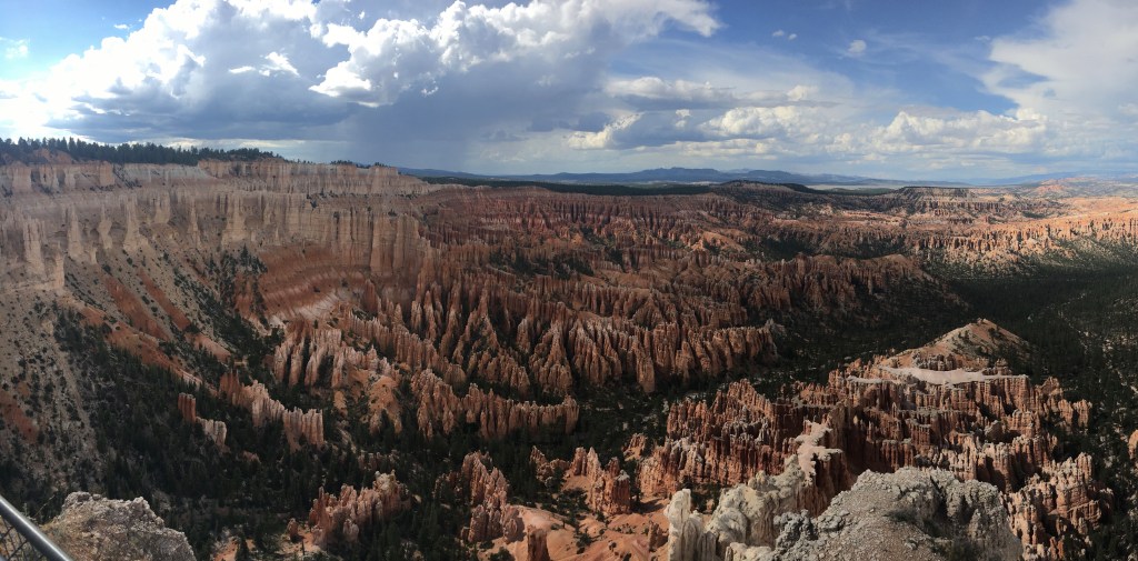
We got to Bryce in the afternoon and took their shuttle bus to a few viewpoints. One of our bus drivers was really fun and told us facts about the park. Bryce has a surprising amount of wildlife and he pointed out dear and prairie dogs along the way. Bryce Canyon is a huge amphitheater filled with rock spires called hoodoos. They form when water gets in the cracks in rocks and then freezes at night, breaking away at the rocks. Bryce canyon has more hoodoos than anywhere else in the world, and this is because Bryce is at a really high elevation so its temperatures allow for the freeze-thaw cycle.

After sightseeing, we went to the RV park where we were staying. The park was surprisingly nice and we relaxed in its hot tub. The next morning we did a hike into the canyon to get up close to the hoodoos. We also got to see the park in morning light, which was very pretty.


Our hike lead us through an area called Wallstreet, where you hike through a cavern between tall hoodoos. Right after it was a steep hike of switchbacks to get back to the rim. I regret not doing the hike in the opposite direction.


Our hike took about 1.5 hours and we had some time to kill so we took the park’s scenic drive to some viewpoints. There was an arch that was cool but after that, they all looked pretty similar. I stopped taking my phone to the viewpoints. Just a lot of hoodoos.


Raven was enjoying the view.
Finally, we got on our way to our next stop, Capitol Reef National Park, taking Scenic Byway 12. This route was really beautiful. I’m running out of ways to describe the views and dessert formations. We stopped at a lookout point called the head of the rocks.

We arrived at our campground, which is a cute place. The owner was sitting on a rooftop porch when we arrived and shouted information down at us about the bathrooms and the wifi password. The campground has a beautiful view (the picture doesn’t demonstrate how red the rocks are). Now we are hanging out before bed.


Leave a comment