
Welcome to my new blog! In this summer between my college graduation and the start of my job, I’m doing an unusual (for me) amount of traveling. From now on, if I go somewhere cool, this is the place to hear about it! I couldn’t keep using my Italy blog because it was too location-specific. I’ve always wanted to see the national parks out west so I’ve embarked on a two-week road trip, half with Duncan, half with my mom, where I will explore some places in California, Nevada, Utah, and Arizona. Exciting!
On Friday night when Duncan finished work, we headed to the airport and boarded a plane to San Francisco. We stayed in Redwood city overnight and got brunch with my parents and brother in the morning. My mom handed off the minivan to Duncan and me, which she had filled with equipment for our trip. This included bedding, a cooler chest, multiple sizes of trash bags, utensils, a first aid kid, a hatchet, and a bin full of homemade cookies. Mom is never short of prepared.

Ty and I got in our classic sibling picture.Duncan and I took off heading east. We saw a lot of hills covered in yellow (dead?) grass and sparse trees. To help pass the time, we listened to Ender’s Game on audiobook. Finally we reached Stanislaus National Forest which is the poor man’s Yosemite. It borders Yosemite to the northwest and has a lot of the same pine forests and stony peaks, but you don’t have to pay to get in. We stopped at a random pull off and found a gorgeous view. At the time I thought it was very nice but the views got a lot better.

Our first planned stop was a called Donnell Vista and I had added it to our itinerary simply because I saw it was right on the road. Turned out to be a great spot. There was a short trail off the parking lot that had a cool view of mountains and a reservior below. We could see that a lot of the forest in this area had been burned.

We stopped at a few random roadside lookouts for views that I thought were too cool to not get a picture of. This lead to a lot of stopping and significantly slowed us down. I don’t think the pictures do justice to the coolness of the views.


Our first serious destination (as opposed to a quick roadside stop) was Mono Lake, which is part of Inyo National forest. This lake is known for its tufas, which are mounds of limestone created from waters bubling up in the lake (or at least I think that’s what the sign said). We originally stopped at one point of the lake that didn’t have tufas and I was adamant about leaving to go to a different part that had tufas. Duncan asked what tufas were and why they were so important, to which I responded that I didn’t know what they were exactly but I knew I wanted to see them.

The tufas turned out to be really cool. It felt like an alien landscape. We learned that the lake is fed by various streams that carry salt and minerals into the lake and they just build up there. Mono lake is twice as salty as the ocean and it smelled briney.

It’s also notable that Mono Lake is right outside of the road that goes to Yosemite and the gas prices there were INSANE. 7 dollars for regular gas!!! At this point we were driving southeast along the Sierra Nevadas. We saw lots of cool, pointy mountains and crazy gas prices. We stopped in a very small town called Big Pine to grab some dinner. I had intended us to do a hike in the Bristlecone Pine forest (part of Inyo National Forest) but at this point it was pretty late and getting close to sunset. We drove towards the pine forest with the hope of doing a sunset hike but it got too dark and we decided to stay at a campground that was nearby so we could do the hike in the morning. We slept in the minivan on an air mattress and it wasn’t super comfortable but it was ok. Much cheaper than a hotel.
In the morning we headed to the bristlecone pines and stopped at a vista point that had a great view of the mountains.

The bristlecone pine trees are the oldest in the world and have been found to be over 4000 years old. Pretty cool! They have some gnarly, twisty branches. We learned that they have pretty shallow roots to be able to get more moisture from the topsoil, but this means that erosion is one of the main things that ultimately becomes their downfall.


Duncan and I got really winded from the hike around the tree grove, which is supposed to be a short, easy walk. We realized it was probably because we were like 10,000 feet above sea level. The Boston altititude has made us weak. We got on the road and started heading towards our next major destination: Death Valley.
I thought death valley was going to be a lot of boring dessert but it was actually pretty spectacular. The mountains around were beautiful and had multicolored layers. Our first quick stop was a point called Father Crowly Overlook, which looks out at a valley. The military does practice here where pilots fly through the valley to practice near-ground maneuvers.

Also saw some fun lizards with black and white stripes around their necks.

There was actually a thunderstorm in the mountains of death valley, which we saw in the distance and then drove through. In the heavy rain I could see streams of silt-filled water coming down the rocks and eroding them. This was cool until it got scary. We saw larger rocks had been broken off in the storm and were blocking the road. We stopped to let a car pass then watched as more, large rocks tumbled onto the road in front of us. We couldn’t drive over them so Duncan got out of the car to move them and I sat inside, terrified that more would fall and hit him or the car. Two other guys in cars behind us got out to help Duncan. I would’ve gotten a picture of Duncan’s heroic act if I wasn’t so scared.

We escaped the thunder storm as we drove out of the mountains and into the proper valley part of death valley. Most of the valley floor looks like what you would expect from an American dessert–flat and covered with scrub bushes–but in the distance I saw tall sand dunes that looked like they were from the Sahara. We stopped at them and getting out of the car felt like getting into an oven. The car thermometer said it was 111 degrees. We didn’t stay for very long.


We got to the town of Furnace Creek, which has the Death Valley Visitor Center. The views from there were pretty cool too. At the visitor center we watched a short documentary about Death Valley and learned that there’s a site called The Racetrack where you can see the path of large rocks that look like they’ve been pushed but no one knows for sure how they moved, and no one has even seen them move. Look it up.


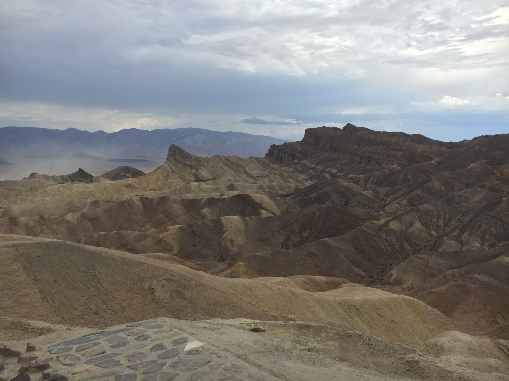
We grabbed lunch at a nearby hotel and headed to our last stop in Death Valley: Zabriskie Point. At this point the thunderstorm we drove through earlier was moving in and Zebraskie Point was insanely windy. Like pushes you over windy. This point was one of the most beautiful things I’ve seen in my life.


In the parking lot for Zabriskie Point, I noticed that a few cars had a bunch of mud splattered on them, as if they’d driven through some puddles. I made a joke to Duncan that those cars might be indicative of what was to come. I was more right than I thought. As we tried to drive out of Death Valley, we found that flood waters had washed out many portions of road. The first time we came across one of these, we saw a few cars waiting in front of it, unsure what to do. We saw someone cross and figured it was ok, so we crossed and were fine. I made a remark that I wished I had gotten a picture of it. Little did I know there would be no shortage of photo opportunities. We crossed at least a dozen of these, and they ranged from streams about 10 feet wide, to portions of the road that were entirely flooded such that you couldn’t see the sides. Duncan heroically drove us through all of this. I had no cellphone service for most of this drive but when I finally got some, my phone lit up with flash flood warnings that told us not to be on the road unless we were escaping the floods. Oops. Too late.


We eventually escaped the flooded roads and made the long drive towards Zion National Park, going through Las Vegas and Arizona, briefly. In Arizona, we saw beautiful rock formations from the highway. They were amazing and also everywhere. If the views from the highway were so good, I wondered how you’d even make a national park out here. Everything could be a national park. I had planned for us to stop for an evening hike but we were too delayed by the road flooding and some traffic we hit. We grabbed some very cheap Mexican food nearby to our hotel and got checked in.

The next morning we woke up early to get started in Zion, but that’s another blog post. Now we’re in Utah, which is where we’ll be for the majority of the trip.

Leave a comment